
POLJT 2026 · SHORT COURSE PROFILE

15K

The 15K route is designed as POLJTs fast-entry jungle challenge: runnable in long sections, technical enough to reward smart pacing, and structured for first-time trail racers and experienced runners chasing controlled speed.

Category
Active / Entry Trail
Effort Level
Moderate, pace-aware
Terrain Type
Jungle trail + rolling climb
Course Character
Flowing, scenic, tactical

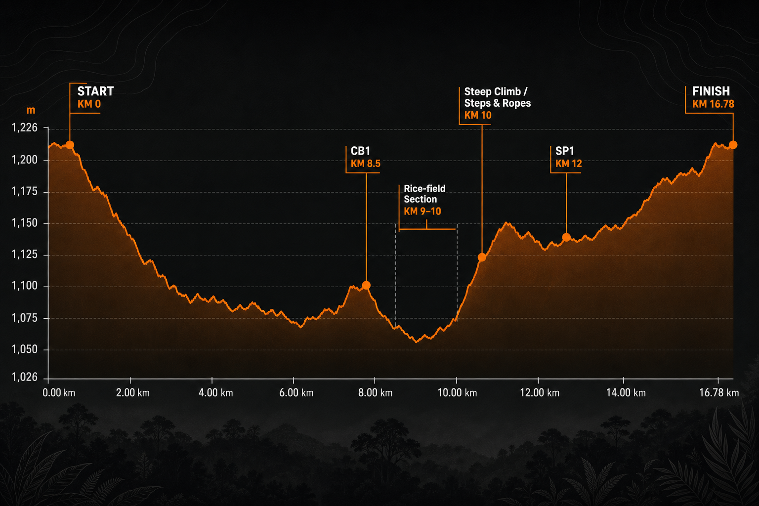
Elevation profile summary

15K Course Briefing

The 15K category will start at 06:30 AM.

At approximately KM 8.5, runners will arrive at CB1. This is a very important course junction, where the three race routes separate.

Please make sure you are following the correct route. If you are participating in the 15K category, follow the 15K course markings carefully. Do not simply follow the runners in front of you.

At approximately KM 9–10, runners will enter a section through the rice fields. The trail is narrow and may be wet and slippery. Please slow down, proceed carefully, and do not attempt to overtake other runners unnecessarily.

At approximately KM 10, runners will encounter a very steep uphill section with steps and ropes for assistance. As space is limited, please maintain a safe distance, avoid crowding, and do not push the runners ahead of you.

15K runners should remember these three key points:

  • CB1: Confirm that you are following the correct 15K route.
  • KM 9–10: Narrow and potentially slippery rice-field section.
  • KM 10: Steep uphill section with steps and ropes—keep a safe distance.

Finally, please pay special attention to the Cut-off Time.

The overall Cut-off Time for the 15K category is 5 hours and 30 minutes.

In addition, each CB has its own Cut-off Time. Please check the Cut-off Time at every CB during the race and manage your pace accordingly.

Know your route, watch the Cut-off Times, control your pace, and finish the race safely.

Recommended approach: keep effort conservative through the opening flow, protect legs on early undulations, then increase rhythm after the highest point once footing stability allows.
Route-map overview

15K Route Map Overview

The POLJT 15K course offers an accessible but challenging introduction to trail running through the natural landscapes of Pyin Oo Lwin.

The race starts and finishes at the POLJT Arena. Along the route, runners will experience forest trails, village paths, narrow rice-field sections, and a steep uphill climb.

At approximately KM 8.5, runners will arrive at CB1, an important junction where the 15K, 30K, and 50K routes separate. All 15K runners must follow the designated 15K course markings carefully.

The rice-field section around KM 9–10 may be narrow, wet, and slippery. Runners will then encounter a steep uphill section with steps and ropes for assistance.

Please study the route map before race day, follow the official course markings, manage your pace, and pay close attention to all Cut-off Times.

Distance: 16.78 KMStart Time: 06:30 AMOverall Cut-off Time: 5 hours 30 minutesKey Checkpoint: CB1 at approximately 8.5 KM

Follow your route, control your pace, and finish safely.

Elevation Profile

15K

Distance

16.78 KM

Elevation Gain

500+ M

Elevation Loss

Not publicly listed

Official POLJT 15K elevation profile chart in wide landscape format on a clean non-picture dark plotting background with subtle horizontal grid lines, UMTR orange elevation line and restrained orange area fill under the curve. Exact Y-axis labels shown: 1,026 m, 1,092 m, 1,160 m, 1,226 m. Exact X-axis labels shown along the bottom: 0.00 km, 1.86 km, 3.73 km, 5.59 km, 7.46 km, 9.32 km, 11.18 km, 13.05 km, 14.91 km, 16.78 km. Curve behavior follows the official reference: start near 1,175 m at KM 0, early descent to around KM 2, climb through KM 2 to 5, notable drop around KM 5 to 6, rolling descent to the lowest basin near KM 9.3 around 1,030 m, renewed climb with steeper rise around KM 10 to 11, rolling oscillations through KM 11 to 16, and strong final climb finishing around 1,175 m at KM 16.78. Clearly labeled markers with non-overlapping callouts and subtle leader lines: START — KM 0, CB1 — KM 8.5, Rice-field Section — KM 9–10, Steep Climb / Steps & Ropes — approximately KM 10, SP1 — KM 12, FINISH — KM 16.78. Start and finish are shown at the same elevation.
  • START — KM 0
  • CB1 — KM 8.5
  • Rice-field Section — KM 9–10
  • Steep Climb / Steps & Ropes — approximately KM 10
  • SP1 — KM 12
  • FINISH — KM 16.78

The elevation profile provides an overview of the major climbs, descents, checkpoints and key technical sections along the POLJT 15K course.

Start time

06:30 AM 

Cut-off time

12:00 PM (5 hours and 30 minutes)

Checkpoints

CP1 at 8.5 KM (Check Point 1)

Aid provided

Core hydration, basic fuel support, and medical response positioning are part of the 15K support plan; the exact station matrix will appear in the final guide.

Checkpoint flow and pacing notes

Early control: settle into your target effort before the first support touchpoint to avoid overpacing on fresh legs.

Mid-course support: use aid/checkpoint windows for short, disciplined refills and quick status checks rather than long stops.

Finish execution: plan your final push after the last major terrain change, prioritizing stable footing and controlled downhill cadence.